
Pit Monitoring Tailings Dams Waste Piles Heap Leach Underground Mines
Remote sensing provides a synoptic, site-wide monitoring solution for mitigating risk over active and abandoned mines. All mine assets can be regularly monitored to provide deformation maps and to detect slope and faults movement.
Mine-Wide Movement and Asset Mapping
Deformation rates can be identified from millimetres to metres can be measured, eliminating the need for the installation of ground equipment.
Pit Monitoring
A long-term monitoring solution to identify in-pit movement, slope instabilities and active faults. We provide two services:
- Rapid Reporting (Weekly / Monthly): Situation report of observed deformation in period monitored and digital map
- Regular (Bi-annual / Annual): Full InSAR analysis, detailed time-series of deformation history and thousands of measurement points
Slope Stability Monitoring and Fault Detection
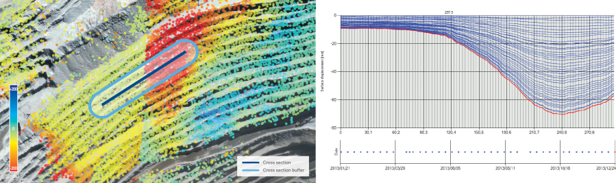
Regular and Rapid Open Pit Monitoring Service: (Left) Dense measurement points over the entire open-pit area highlight in-pit movement, slope instabilities and active faults. (Right) Cross-section analysis slices through the data for in-depth analysis and the identification of movement boundaries. Red measurement points indicate movement away from the satellite (typically subsidence), green indicates stability and blue is towards the satellite (typically uplift) [Img src TRE-Altamira]
Tailings Dams, Waste Piles & Heap Leach
Reduce risk and health and safety concerns by regularly monitoring remotely, especially where there is limited access for conventional survey techniques. No need for ground instrumentation.
Tailings Dams

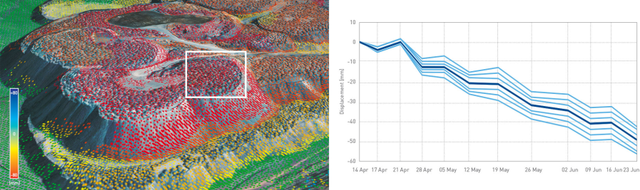
Tailings Dams Monitoring: A high density of measurement points allows accurate stability monitoring of the top and side faces. Cross-section analyses highlight areas of concentrated deformation [Img src TRE-Altamira]
Waste Piles
Waste Pile Monitoring: A high density of measurement points allows accurate stability monitoring of the top and side faces of the waste piles. Time-series of deformation highlight the temporal evolution of instabilities and aid risk management [Img src TRE-Altamira]
Heap Leach

Heap Leach Monitoring: Settlement rates can be monitored without impacting operational activities and without requiring ground instrumentation [Img src TRE-Altamira]
Underground Mines
Accurately detect, map and quantify subsidence rates from millimetres to metres over active and abandoned mines.
Longwall Mining |
Block Caving Mines |
Abandoned Mines |


Underground Mine Mapping (left to right): Longwall mined coal seam monitoring, Block caving mine, Abandoned mine [Img src TRE-Altamira]
Angle of Draw Analysis
By observing the surface subsidence (C) over an old mine (A) and an active mine (B), knowing the operating depth, an accurate Angle of Draw can be calculated.

Angle of Draw Analysis [Img src TRE-Altamira]
[Back to top]
