Tunnels Roads Railways Airport Bridges Pipelines Buildings Power Plants Dams Flood Defences
Our range of technologies means we can service planned and active civil engineering projects with site stability monitoring, as well as providing cost-effective situational awareness solutions and site potential information for new urban infrastructure networks.
Ground Displacement Monitoring for Civil Engineering
We provide an ‘all-stage’ monitoring solution for engineering projects: from design to the construction and operation phases, providing unique support in surveying both overground and underground construction sites.
Design & Baseline Construction & Stability Operation & Settlement
InSAR does not require any ground-based instrumentation but yet produces a significantly higher density of measurement points compared than traditional ground-based surveys (e.g. GPS, levelling, total stations).
Design & Baseline
Historical ground motion can heavily impact on new constructions projects. To mitigate potential risk and determine wide-area baseline stability / instability maps, historical satellite imagery archives can be exploited for site characterisation and to reconstruct past ground movement. This approach can assist in planning new:
For linear structures such as roads and railways, a one-time baseline analysis minimises survey time and cost compared to traditional survey techniques. Highway Planning – Baseline Subsidence Mapping: Past ground movement can be reconstructed using historical satellite data to provide numerous years of baseline stability data for new and planned projects. Red measurement points indicate movement away from the satellite (typically subsidence), green indicates stability and blue is towards the satellite (typically uplift) [Img src TRE-Altamira] |
 |
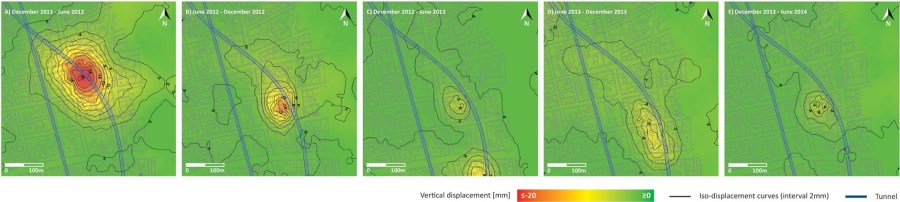
Construction & Stability
Satellite monitoring enables engineers to accurately and regularly determine the impact of ongoing ground works on the stability of the excavation area and the surroundings. With thousands of measurement points with each analysis and covering a wide area, satellites are a cost-effective monitoring technique compared to traditional methodologies.
Detect Millimetre Displacements over Ongoing Ground Works
Satellite images are acquired every few days, allowing a full reconstruction of ground movement to be compiled and verifying that predicted deformation corresponds to actual deformation.
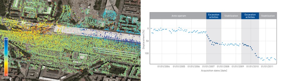
Monitoring Ongoing Construction Works: (Left) Ground movement over active construction projects can be regularly monitored using InSAR and can rapidly quantify and highlight the extent of millimetre ground displacements over the works and surrounding area. (Right) A time-series of ground movement allows displacements to be rapidly quantified and stabilisation efforts confirmed. Red measurement points indicate movement away from the satellite (typically subsidence), green indicates stability and blue is towards the satellite (typically uplift) [Img src TRE-Altamira]
Operation & Settlement
Regularly monitoring of new completed structures and work sites will identify and quantify ground settlement, highlighting potential structural weaknesses and providing a rapid information source to aid engineers should remedial actions need to be taken.
Assess Settlement and Control Impact on Assets
Accurate maps of ground stability can be used for identifying areas at risk that could impact on existing structures.